马上注册,免费下载更多dz插件网资源。
您需要 登录 才可以下载或查看,没有账号?立即注册

×
The densest part of the ocean's mid-depth line is the continental slope. An isobath is a closed curve formed by connecting points of the same depth in an ocean or lake, which is scaled down and projected vertically onto a plane. An isobath has the same depth at points on the same isobath. Sea water depth refers to the vertical distance between the depth datum and the seabed, and the average low water level is usually used as the depth datum. It is mainly used to show the depth and topography of the ocean in the map.There are three kinds of isobaths on the chart: basic isobath, supplementary isobath and imprecise isobath.
The densest isobaths in the ocean are on the continental slope.Isobath is the curve formed in an ocean or lake where points of the same depth are connected into a closed curve, scaled down and projected vertically onto a plane, and the resulting curve is called an isobath.Isobaths have equal depths at each point on the same isobath.The sea depth is the vertical distance between the depth datum and the seabed, and the mean low tide surface is usually used as the depth datum.It is mainly used in charts to represent ocean depth and topography.There are three types of isobaths on nautical charts: basic isobath, subsidized isobath, and imprecise isobath.
©DZ插件网所发布的一切资源仅限用于学习和研究目的;不得将上述内容用于商业或者非法用途,否则,一切后果请用户自负。
本站内容为站长个人技术研究记录或网络,不提供用户交互功能,所有内容版权归原作者所有。您必须在下载后的24个小时之内,从您的电脑中彻底删除上述内容。如果您喜欢该程序,请支持正版软件,得到更好的正版服务。
您在本站任何的赞助购买、下载、查阅、回复等行为等均表示接受并同意签订《DZ插件网免责声明协议》。
如有侵权请邮件与我们联系处理: discuzaddons@vip.qq.com 并出示相关证明以便删除。敬请谅解!
|
|
 TAG标签自动获取SEO 1.6.3(exx_tagseo)1508 人气#Discuz!插件模板
![克米设计-APP手机版v3.6全套插件模板2025版再更新版干净优化版[大量美化优化整理版 20250305版]](https://static.dz-x.net/block/95/95034d6ef29f6ae26b0087e331184515.jpg) 克米设计-APP手机版v3.6全套插件模板2025版1059 人气#Discuz!插件模板
克米设计-APP手机版v3.6全套插件模板2025版1059 人气#Discuz!插件模板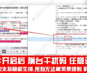 Discuz!加固防采集+干扰码 手机+电脑商业版515 人气#Discuz!插件模板
 [通用绝版插件】二级横竖导航栏 1.21 人气#Discuz!插件模板
 风格切换2.0(e6_style)支持X3.4 X3.552 人气#Discuz!插件模板
![用户动态滚动弹幕 2.7(popbarrage)[仿LightSNS]](https://static.dz-x.net/block/e2/e2439b427212896c654c3ec5c459c826.jpg) 用户动态滚动弹幕 2.7(popbarrage)[仿Light1781 人气#Discuz!插件模板
用户动态滚动弹幕 2.7(popbarrage)[仿Light1781 人气#Discuz!插件模板

 AI智能体
AI智能体
 |最近更新|Archiver|手机版|小黑屋|DZ插件网!
( 鄂ICP备20010621号-1 )|网站地图
|最近更新|Archiver|手机版|小黑屋|DZ插件网!
( 鄂ICP备20010621号-1 )|网站地图

 提升卡
提升卡 置顶卡
置顶卡 沉默卡
沉默卡 喧嚣卡
喧嚣卡 变色卡
变色卡 千斤顶
千斤顶 照妖镜
照妖镜


